Our original plan was to hike it in three days, mainly because you need to time your hike to the tides. Three sections of this hike are impassable when high tide arrives, so we figured we'd need three days to time our beach traverses just right. Turns out we hiked a lot faster than we expected (we're used to White Mountain trails with all those boulders and roots, therefore flat sand feels fairly easy), so we actually did the trip in two days with just one overnight.
The Lost Coast Trail begins at the Mattole trailhead 25 miles north of Shelter Cove, CA and ends up in...well...Shelter Cove. There are a few commercial transport services one can use to get you from one end of the trail to the other. We used Bill's Lost Coast Shuttle. "Wild Bill," as he is known locally, has lived in Shelter Cover for decades and was shuttling people to and from trailheads before the Lost Coast Trail became a popular thing. Wild Bill does not have a website -- you call, make the arrangements, and your word is your bond (he does not ask for a deposit). I liked dealing with Bill. He's old school. Don't worry that he doesn't take advanced payment or that he doesn't have a website. He'll call to confirm your booking a couple of days before your scheduled pick-up date, and he'll show up at the trailhead right on time. He also gives you a free map and a free print-out of the tide schedule for the exact days of your trip...something I don't think the other shuttle services do. His rate is the same (or less if there are more people in his van to share the ride) than the other shuttle services.
By the way, you need a permit for this hike, and you need to carry a bear canister, You can rent canisters from Bill, and you can get a permit here.
We readied our gear and spent the night in Shelter Cove, then drove to the Shelter Cove trailhead overnight parking (free!) and waited for Bill, who showed up right on time at 7am.
The drive to the northern trailhead takes around two hours; the roads are narrow, windy, and steep. Bill asked if we needed motion sickness pills for the ride (we didn't), and then he drove fast and furious (like locals do) to the trailhead. I enjoyed talking with him during the ride. He was full of great info and fun conversation.
We arrived at the Mattole Trailhead around 8:40 or so.
We said goodbye to Bill, then off we went. The weather was sunny, dry, and a bit windy.
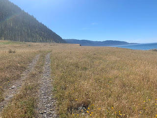
The trail was mostly sand during the entire hike. Sometimes it was fairly packed, and sometimes it was fairly loose. It was an interesting workout for the legs.
There were a few instances of having to walk through vegetation that was waist high on both sides and that contained poison oak -- our long pants kept the poison oak off our skin. Highly recommend long pants for at least the first half of this hike (I don't remember much if any poison oak on the southern half).
There's a lighthouse a couple miles in from the northern trailhead.
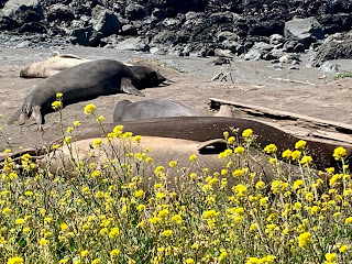
Just past the lighthouse, we had a close encounter with a colony of California sea lions. They were right there, just a few feet to the right of the trail, laying about and sometimes flicking sand on themselves with their tails.
On we walked, through the sand. All three of us were careful to watch out for "sneaker waves." We had been warned, both by Bill and by signs everywhere, about not turning our backs on the ocean. The coast where we were is not like the NH coast; the water has dangerous riptides, and there are plenty of large waves that seem to spring up from nowhere and can pull unsuspecting hikers into the ocean. We didn't fall prey to any of these waves during our hike.
Halfway through our first day, we came across this adorable little guy. Thankfully, we had seen a sign at Shelter Cove explaining that mamas leave their babies on the beach while they go off to fish, and that the mamas come back later. There is nothing wrong with the little fella, and no one should come close to or bother the baby sea lion. The mama will come back, so just keep your distance and move along. We did pause for a minute to ooh and aah because this guy was so cute, but we didn't get close and we went on our way when the baby became too interested in us.
On we went. Sometimes the trail would come up into the grass beside the beach (the footing was much firmer here), sometimes we'd hike over pebbles and rocks, and sometimes we'd be in the sand itself.
A colony of sea lions on the rocks.
There are a couple of private cabins here and there, with little roads running to the property (from where, I'm not sure). At times, the trail shares a piece of the little dirt roads...
Past forest fire area...
One thing we each really should have brought was a sunhat. We are not used to hiking totally out in the open -- it's been a while since we had to worry about constant sun exposure (the John Muir Trail in 2014 was the last time we were totally exposed to the sun all day every day -- in NH, we're in the trees most of the time). This meant all three of us got completely sunburned unfortunately, in spite of our fairly consistent application of sunblock.
We made it across the first two cross-at-low-tide-only sections before the tide came in on our first day, and we found ourselves looking for a good camping spot much farther along the trail than we'd expected (we had thought we'd camp before the second danger-at-high-tide section).
We found a spot right on the beach, in a section where the high tide does not reach, right next to a fresh water creek (there's fresh water coming to the ocean every mile or two).
The view from our tent --
Unfortunately, there was a strong wind that evening that kept flattening our tent...we therefore decided to just sleep on top of it. There were no mosquitoes and the forecast was for a dry night, so we cowgirl-camped.
Our view of the sunset...
Day Two -- June 9, 2019
There was no need to rush at all on this day, since we were starting the day much farther along than we'd planned. We would be able to make it across that third "cross-at-low-tide-only" section without any problem at all, and we'd likely be back at the car in Shelter Cove by early afternoon. We do hike at a fast pace when not in NH -- seriously, all those boulders and steep grades and rocks and roots make hiking everywhere else feel so much easier.
We had a bit of rock-hopping to do in the morning, but it was nothing a northern Presidential hiker can't easily handle.
We came across this young seal. This is a zoomed-in photo -- we didn't get close.
When we came to this section, it was possible to see Shelter Cove far in the distance.
More sand, more dirt driveway of isolated cabins...
The Black Sand beach of Shelter Cover was the most difficult walking of the entire trip. None of it was firm. We were happy to see the buildings of Shelter Cove itself.
Almost finished! Shelter Cove is right behind us.
Done! On the boardwalk that leads up to the overnight parking area.
We enjoyed this -- it's a good hike if you have only a few days and you want a long walk by the ocean. Lots of California sea lions, seals, birds, and sometimes whales (we didn't see any, but apparently the ocean right here is a migratory route for grey, humped-back, and killer whales).
We've always hiked mountains and forests and hilly countryside -- this was our first beach hike. It was nice to do something different, and I was glad we could fit this in during our West Coast college visit experience.


No comments:
Post a Comment